Tag Archives: Inland Empire

San Bernardino Transit Center Celebrates One Year of Service

wp-1473652650531.jpg
One artist used Omnitrans’ old logo as part of his drawing. Photo: author/iNLand fIEts.

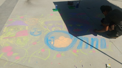
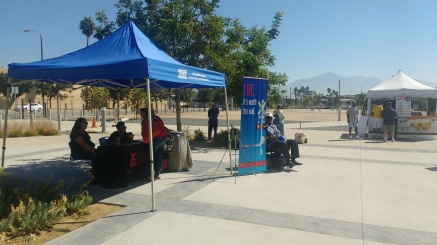
This past Saturday, visitors to the San Bernardino Transit Center (SBTC) were treated to a tunes, a cold drink, and a place to rest between buses as Omnitrans held a party to celebrate the first year of operations of the SBTC. As local all-girl band Alive in the Lights rocked out under a cloudless sky, members of the community participated in a chalk art contest in the plaza in front of the SBTC. Artists were competing for a $250 grand prize and they brought their A-game with many great designs. As they drew, they were entertained by antics provided by the SANBAG See Tracks, Think Train campaign mascot  out spreading the word of practicing safety around tracks.

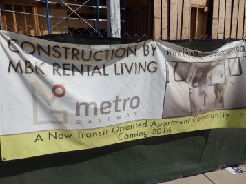
A little over year ago, on August 24, 2015, that dignitaries and curious onlookers stopped by the soon-to-be-completed SBTC in the eponymous city to celebrate the grand opening of the new transfer and customer service facility. The anticipation turned to excitement on September 8, when the SBTC officially opened to the public. Envisioned by Omnitrans since the 1980s, the Transit Center replaces the transfer hub that had floated around the 4th St. area of downtown San Bernardino for decades.

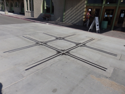
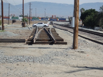
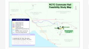
It brings together almost all of their East Valley service into one central location, providing connections to the sbX Green Line, MARTA Off the Mountain service, VVTA BV Link, (as of today) Pass Transit Commuter Link 120, Metrolink by the end of next year via the under construction Downtown Passenger Rail Project, and the Redlands Passenger Rail Project which is projected to be open by 2021. However, the coordination to ensure those connections are available and make sense did delay the completion of the TC, which was originally supposed to open before or at least in conjunction with sbX. At some point in the distant future, CA high-speed rail may also arrive at the site, which would truly awaken the city.

The facility has a staffed customer service desk and 24/7 security to maintain peace and order. Omnitrans has thus far received largely positive reviews of the facility from the riders, many of whom really appreciate the fact that there is an indoor waiting area, public bathrooms, and connections all in one place. The lobby isn’t a grand hall, but it’s design is functional and elegant and provides travelers a much-needed respite from the elements, especially those who are waiting for connections to Omni’s services that run at only an hourly frequency.

However, not everyone is completely happy with the TC. In addition to the usual complaints about the use of tax dollars for public transit, several people have expressed concern about the lack of parking provided at the site. This is certainly an interesting argument because, realistically speaking, there are few instances where Omnitrans’ local service provides a travel time that is superior to that of driving and most of them are not really in the areas around downtown San Bernardino. As such, it doesn’t seem very likely that many people would drive to park and take the bus, something which is already borne out by the parking lots that Omnitrans built for the sbX Green Line that are 99% empty 99% of the time. Building another lot at the TC for bus passengers doesn’t seem necessary and Omnitrans was right to not do so.

wp-1473652641726.jpg
In the future, Omnitrans hopes to bring a transit-focused development to the empty lot seen behind the canopies.

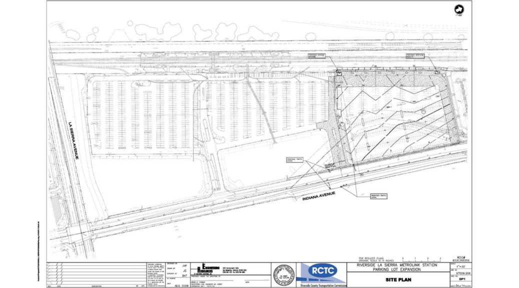
Not doing so also meant that they have space that is available for development on the site that will be easier to convert to that use from an empty lot than it would be from a designated parking lot. However, since the TC is also going to connect to Metrolink, parking will be provided in conjunction with the completion of that portion of the project. Additionally, 10-minute drop-off parking is available on Rialto Ave. at the front of the TC. Furthermore, there are literally dozens of acres of surface lots available within a two block radius of the site that could be tapped with some sort of agreement to provide parking for the TC if it’s truly necessary, including over 13 acres directly adjacent the TC at the San Manuel Stadium.

While parking for cars at the TC isn’t plentiful, there is a decent amount of bike parking strewn around the site, albeit of mixed utility. The good part about it is that it is of an inverted U shape and square, but unfortunately, the racks themselves were installed far too close together, rending them partially useless. In addition to the bike parking, the TC is also host to the San Bernardino Bike Hubitat co-op shop. Since opening in May, the Hubitat has helped hundreds of Omni patrons continue rolling.

In the next few years, the SBTC should see an increase in use as more transit connections come online. However, most of the ultimate success for the Center rests squarely on the shoulders of the City. As they look to exit bankruptcy, they have the opportunity to really become a regional powerhouse and world-class city with smart investments and leadership. The coming transit connections provide an extremely advantageous starting point, but they still need to really take the reigns and look forward to the future. Hopefully, that realization happens soon and we can look forward to many more anniversary celebrations.

Progress Report: Downtown San Bernardino Passenger Rail Project

Work is humming along on SANBAG’s project to extend Metrolink service from the current terminus at San Bernardino’s Santa Fe Depot to the Transit Center in downtown San Bernardino. This move of a little over a mile will bring new options and connections to transit users from San Bernardino and many surrounding communities. Though it opened last year, the Transit Center currently only has connections with fixed route bus and BRT service. Once open, this project will provide the first passenger rail service to downtown San Bernardino in at least 70 years.

OLYMPUS DIGITAL CAMERA
The switch that will be installed just north of Rialto Ave. is under construction. All photos: author.

Over the last year or so, the construction phase of this project has been ongoing, with changes slowly manifesting themselves all through San Bernardino’s Lytle Creek neighborhood. By far, the biggest changes are of the transportation right-of-ways. The DSBDPRP is double-tracking the entire loop from the Short Way Subdivision, through the BNSF San Bernardino yard past the Santa Fe Depot, then onto [what remains of] the Redlands District to just past G St., where it splits to provide a third track at the Transit Center and otherwise rejoins the existing double-track segment. The double-tracking will allow trains to freely flow from the Transit Center to the yard that is located about two route miles away in Colton.

In addition to the double-track, two grade crossings are being closed by the project: 3rd St. at the tracks and I St. south of the tracks (the intersection with Rialto from the north remains as a right in/out). The closures aren’t completely bad as especially with I St., it provides a great opportunity for a modernization project on an otherwise chronically overbuilt street. However, it appears that they closures will also cut the neighborhood access off, so that is a bit of a loss to the community.

OLYMPUS DIGITAL CAMERA
One of the cross tracks from the Colton Crossing embedded in front of the Santa Fe Depot.

The Santa Fe Depot itself is also seeing some upgrades. The project is rebuilding the passenger boarding experience to be run-through to allow all trains to be able to continue on to the Transit Center. This includes an overpass of the tracks. But there have been other changes to the outside. Most significantly, the area in front has been altered to more parking away from directly in front of the building to showcase the entrance and really give a more stately look to the building. A nice walkway now leads directly to the front door and a crossover from the Colton Crossing has been embedded in the concrete directly in front of the building. There is also a pad and stop for the Amtrak Thruway bus service that makes daily stops at the station.

OLYMPUS DIGITAL CAMERA
The completed switch awaits installation as work on the second track continues.

Finally, farther west, work has begun on the full extent of the double-tracking. Just north of Rialto Ave., workers have been putting together the switch that will provide the start of the double-track segment that goes through to the Transit Center. Additionally, fencing has been installed at the end of King St. to seal the corridor and keep people off the tracks. While the IEOC Line is the only scheduled Metrolink service to use the Shortway Sub, it is also the connection to the yard, so nearly 50 trains per day will pass through the area to reach the yard in Colton.

Ideally, there will be no major snafus as the year winds down and soon after we ring in the new year, we can begin to take advantaged of one of the most important transit connections in the Inland Empire. Already three years behind, it can’t open a moment too soon. In tandem with the coming Redlands Rail, mobility options in the East Valley are really set to be substantially improved. Hopefully, the cities in the region will be willing and able to properly manage the opportunity that they’re being handed.

More Parking, Apartments Headed for Riverside’s La Sierra Metrolink Station

Transit and transportation agencies pay a lot to provide the patrons somewhere to store their car while they use the service, despite the dubious results, and these parking lots consume a lot of land. Yet, even in the face of oversupply, agencies continue to push forward with plans to expand parking options at stops and stations. One member of that club is the Riverside County Transportation Commission. Back in March, they took comments on a plan to add over 500 more spaces to one of the stations along the Metrolink 91/Perris Valley and IEOC lines. This expansion would occur on an agency-owned vacant lot directly adjacent the existing parking lot.

OLYMPUS DIGITAL CAMERA
The apartments under construction as seen from the southeast. Due to the bluff, they are around the same height above the street as the homes.

In addition to the 500+ spots planned for transit passengers at the station, the Metro Gateway project is currently under construction on two other pads at the station. This development will add 187 units to the neighborhood, but despite being directly across the lot from transit, will also include nearly 300 more spots for the residents and their visitors. That brings the total number of new spots at the station up to about 800, not just the 500 planned by RCTC, an increase of around 75%.

A recent parking audit of the station found around 100 free spaces at 8:30 AM, representing an occupancy of greater than 90%. However, because there are no trains heading west between 7:40 and 10:40 and only one heading east at 9:21, it’s reasonable to assume that the 8:30 numbers represent a daily peak, though it is plausible to believe that some of those spaces might be used by students attending CSU Fullerton when the school year starts. Nevertheless, there continues to be space available and the recent opening of the extension of the 91 Line to Perris added nearly 1700 more spots to the total available in the area around Riverside.

OLYMPUS DIGITAL CAMERA
Putting up signs that say “transit oriented” doesn’t automatically make something actually transit-oriented, even when built by a train station.

Meanwhile, though it’s being billed as TOD, the Metro Gateway development would be better described as transit-adjacent development. In addition to the exorbitant amount of parking included, Metro Gateway lacks any visible signs of incorporating a mix of uses that would bring life to a site that is realistically devoid of life. While there is a retail plaza already located across La Sierra Ave. from the station where the new residents will likely be able shop as well as a bowling alley next door to the north, including some office/retail/light industrial space as part of the project would’ve been really helpful for improving the current parking crater around the station more than just some apartments will. Doing so would’ve been a great way to make the La Sierra Station more than just a pair of platforms and a parking lot, but perhaps even eventually providing space that could be used for satellite classes offered by the namesake school.

It’s disappointing to see that RCTC continues to feel that even in the heated SoCal housing market, the best use for prime land near transit with service directly to LAUS, Oceanside, Riverside, and San Bernardino is to let people store their cars to ride said trains. The biggest upside to a parking lot is that it is relatively easy to replace them with something better in the future. But still, even at present, if RCTC thinks having that much (free!) parking there is really necessary, it should be consolidated into a parking structure on the site to enable other development on the remaining parcels. The station area could easily support a vibrant community around it if only some forethought and creativity were used. Hopefully, this is a wake-up call to that end as RCTC still has several other parking lots throughout the county.

More photos of the site and project are available here.

SANBAG Releases I-10 HOV/HOT Lanes Draft EIR for Public Comment

The clock is now ticking after San Bernardino Associated Governments (SANBAG) finally released the Draft Environmental Impact Report for the proposed I-10 HOV/HOT lanes this past Monday, April 25. With the comment period closing June 8, interested parties have just a little over a month to review and weigh in on several gigabytes worth of information. SANBAG really should’ve taken the proactive step and opened up for a 60-day comment period, but that ship is likely sailed. In either case, there will be a more in-depth review of the proposed projects at a later date, but it’s important to get the word out about the comment period.

A quick glance through the Executive Summary shows a project steeped in the height car-centric planning and design that has led to a region consistently ranked as highly sprawled and that is completely out-of-line with state goals and the economy of the 21st Century. Though the No Build is provided by way of comparison, the report focuses on the two build alternatives: extending the existing HOV lane from Haven Ave. in Ontario to Ford St. in Redlands or constructing HOT lanes from the LA/SBD county line through to Yucaipa. Those options come with a price tag of around $660mn or $1.7bn respectively, but either figure is almost certain to increase after more involved design and construction activities are undertaken.

Those price tags might ultimately be this project’s undoing. Although San Bernardino County’s Measure I allocates funding specifically for a HOV lane on I-10, it will likely not be anywhere near enough to cover the full cost of that alternative. Additionally, as the State continues to cut funding from transportation projects due to the volatility with gas tax income (which is set to enter free fall soon) as well as an increasing focus on moving the transportation paradigm away from its car-centric focus, it seems increasingly unlikely that SANBAG would be able to procure many State funds for a project so diametrically at odds with the State’s goals. Perhaps they will be able to get more luck out of the Feds, but even the USDOT has realized that we can’t build roads indefinitely.

This Draft EIR also provides some insight into recent reports that SCAG* is frantically fighting to delay the implementation of SB 743, which will replace LOS with VMT as a significant impact under CEQA, and is another prime example how other agencies are hampering Caltrans’ efforts to modernize. SCAG’s Transportation Committee is chaired by a representative from Ontario (by way of SANBAG), a city right at the literal crossroads of this project and a similar proposal for I-15 and where a sprawling new community of over 46,000 homes is currently under construction. The Executive Summary casually mentions that the two build options are forecast to result in a 3% (HOV) or 10% (HOT) increase in VMT, something which the forthcoming CEQA thresholds would certainly consider a rather significant impact in need of mitigation since they aim to set a threshold of significance at 15% below baseline. Needless to say, SANBAG and its member jurisdictions are not interested in being told that they need to reign in the parade of building more freeways and overbuilt stroads that dice up the region, even as they struggle to maintain what already exists.

Of course, a project this large has not gone ahead completely unnoticed. While the HOV option was expressly included in the Measure I extension that was passed way back in 2004 with around 80% support, the HOT option was not. Not surprisingly, SANBAG is seeking to get more bang for the buck by leveraging that money with private investment to build and operate the HOT option. However, the prospect of including tolls has piqued the interest of the Tea Party in the area, who have continued to turn out in force to protest this “Agenda 21 plan to force us out of our cars”. Considering that SANBAG and its member jurisdictions continue to build and widen roads with reckless abandon [PDF], that claim couldn’t be further from the truth. At the same time, they are attracting some public interest against the project, which may ultimately prove to be a blessing in disguise if it delays or stops the project.

As mentioned above, a far more in-depth (and boring) look at the project will be undertaken at some point in the future. But for now, it’s imperative that everyone head over to the project website, http://www.1015projects.com, access the Draft EIR documents, and comment on it. Though considering the size and magnitude of the document and project, it would be nice if SANBAG would extend the comment period, that doesn’t seem likely, so look and comment early. Comments can be sent to the following address:
Aaron Burton, Branch Chief, Caltrans District 8
Attn: I-10 CP Draft EIR/EIS Comment Period
464 W. 4th Street
San Bernardino, CA 9240

*Though SANBAG is large enough to be an MPO itself, the regional MPO is SCAG.

Evaluating RCTC’s Coachella Valley Rail Proposals

For a little over a year, the Riverside County Transportation Commission has been undertaking a study to explore the possibility of providing daily passenger rail service to the Coachella Valley. This is at least the seventh time in nearly 30 years that the concept has been explored. (Previous studies of all or parts of the potential route were the focus of or included in other efforts previously completed in 1991, 199319992005, 2010, and 2013.) But with this being take seven on the project, perhaps it’s time to figure out exactly what needs to be done to get this plan off the shelves and to see trains rolling.

The elephant in the room continues to be that the only truly viable alternative to reach the area is by routing passenger traffic through the Union Pacific Yuma Subdivision that heads east from the Colton Crossing. As one of the two principal freight rail arteries in and out of SoCal heading east, Union Pacific understandably has concerns about the proposition of running an increased number of passenger trains over their rails. Currently, Amtrak’s Sunset Limited operates through the corridor, but it is only thrice-weekly service with late night/early morning stops in the area–hardly usable by the majority of potential travelers.

The latest report provides five Alternatives along with reasons for/against them. As the Yuma Subdivision is the only existing route to the Coachella Valley, all the differences occur from the Colton Crossing to LAUS. The five Alternatives (resulting in six total possibilities) are to use the BNSF San Bernardino Sub (Alternative 1), use the UP LA Sub (Alternative 2); use the UP Alhambra Sub (Alternative 3), use two variations of the Metrolink San Gabriel Sub (Alternative 4), or use a hybrid option blending Alternative 4B and 3 (Alternative 4). Four of those options made it through the course level screening to a more detailed analysis and will be expounded upon: 1, 4A/B, and 5.

Alternative 1

As mentioned above, west of Colton is where the differences lie. Of the four potential routes advanced to fine-level screening, Alternative 1 was the only one looked on favorably and advanced to the level of further planning/EIS. Several factors in its favor exist including most principally, a corridor population that is around 25% higher than the others have or would provide in the near-term. Though all study is being done using the assumption of Amtrak service similar to the existing Pacific Surfliner, this proposed route would be the functional equivalent of extending the Metrolink 91 Line out to the Coachella Valley and would in effect, be adding a limited stop train from LAUS to Riverside. Ideally, the Rail2Rail program should be implemented over that portion of the route to allow people to take advantage of that option. From Riverside, the train would then continue north to the Colton Crossing, where it would turn east to reach Indio as outlined above. RCTC currently still has quite a few unused daily allotments for the route, so implementing service via Alternative 1 would only require buying (or leasing) the trainsets and building a few stations. This route also has the second-fastest projected travel time and high ridership.

Alternative 4A

The second Alternative considered at the fine level is branded 4A. This option would be routed primarily over the San Gabriel Subdivision, which is owned by LA Metro and SANBAG for operating Metrolink’s San Bernardino Line. However, the San Gabriel Sub is at present, not directly connected with the Yuma, so this option requires several things be done to make that connection. The proposal calls for squeezing a track to connect to the northbound BNSF line between I-10 and the Colton Crossing and also just continue it through Colton to connect to the Metrolink Short Way Subdivision that is used by the IEOC Line to reach San Bernardino and Metrolink to access their Colton yard. A flyover would then be built to connect that track with the San Gabriel Subdivision and the report also calls for the two segments of double-tracking already underway to be built. This Alternative would have Inland Empire stops at Rialto and Montclair before heading to LA over the same route used by Metrolink. According to the analysis, this option would produce the fastest travel time of 3:06 as well as the second-highest ridership.

However, it was ultimately, it was not selected for further study due to requiring a minimum investment of $141mn more than Alternative 1 and potential ROW issues, including relocating a trucking facility at the BNSF San Bernardino yard. But looking at the reality of the area, a connection could probably be built to connect to the existing flyover and thus avoid relocating the majority of the trucking yard. Presumably, some of the money would also go into the double-tracking projects mentioned above, but it’s primarily slated for providing the connection to the BNSF tracks and Short Way in Colton as well as the flyover to connect with the San Gabriel Subdivision. Additionally, at least two actual bridges would be required (one over La Cadena, one over Lytle Creek) and though there is a little room for it, adding a fourth track through Colton will require a couple things to be moved and at least two more grade crossings be expanded. Though not studied in the report, the Colton track does provides an opportunity for a Colton stop to be added to the IEOC Line and potentially the CV train as well.

Alternative 4B/5

The last two Alternatives, 4B and 5, are functionally the same, so they’ll be looked at in tandem. Both would use the same connection in Colton as presented by 4A to reach the Short Way, but would instead utilize the San Bernardino Downtown Passenger Rail extension to continue all the way into the recently completed San Bernardino Transit Center located downtown. Going to the SBTC would provide connections with numerous transit services serving the San Bernardino Valley, Mountain communities, and Victor Valley areas. This option also avoids the need for a flyover in the BNSF yard, but leaves the recommendation for the double-tracking along the San Gabriel Sub. However, the train would have to switch ends in San Bernardino before being able to continue to LAUS. According to the report, this maneuver can take up to half an hour, so accommodating it is projected to likely necessitate another layover track be added to the site. The layover also effectively cuts the journey into two separate trips. That could be great for station-area businesses in San Bernardino, but results in a major hits on ridership and travel times. Unsurprisingly, these two options have the longest scheduled travel times but lowest ridership.

The rest of the route is for Alternative 4B, identical to Alternative 4A. Alternative 5 instead uses the UP Alhambra Subdivision into LAUS from near the El Monte station which provides a potential bypass of the single track line on I-10. Both 4A and 5 would differ from 4A in that they would not stop at Rialto, only at Montclair. Additionally, 5 require second flyover in El Monte to provide access to the Alhambra Sub without running into freight congestion. Course-level screening indicated that Alternative 5 would require double-tracking of the Alhambra, but the ongoing Alameda Corridor East San Gabriel Trench appears to be taking care of that. Still, in comparison to Alternative 1, these two options have a potential cost of $130mn more for 4B or $162mn more for Alternative 5. Due to both the cost but especially the turn time depressing ridership, these two Alternatives were also nixed from further configuration.

Results

Perhaps unsurprisingly, Alternative 1 has been selected for further study and advancement to the EIR/EIS stage. This is the only Alternative that would actually serve the City of Riverside, which, notwithstanding the relative lack of necessary investment compared to the others, likely was a part of the deciding factor for its favorable consideration in a study commissioned by RCTC. Progress toward those environmental documents is undoubtedly being worked on now. Additionally, though Measure A doesn’t put much money toward rail, cap and trade money might provide the ability to acquire equipment and start the service. With new locomotives on the way for the Surfliner and Metrolink, there will probably be some surplus power available in the LA area soon that, pending funding, can be leased for a decent price to get things rolling within a few months of final approval of the environmental documents. Hopefully, that can happen before the 40th anniversary of the first study.

SANBAG Slowing Chugs Ahead with Metrolink Double Tracking

Yesterday, the SANBAG board of directors approved a motion directing staff to begin searching for a firm to complete an environmental document and 30% design for a chronically needed double-tracking of Metrolink’s San Bernardino Line. This comes after it zoomed through the agency’s Commuter Rail & Transit Committee last month. The proposed segment of double track will be a pivotal piece of infrastructure that will allow Metrolink to better serve and grow the corridor with the highest ridership.

Screenshot 2015-11-26 21.19.49
The Metrolink San Bernardino Line Twitter account (@MetrolinkSB) is an ongoing chronicle of the innumerable near-daily cascading delays caused by the  prevalence of single track on the route.

The biggest improvement will undoubtedly be the ability to ease congestion and decrease some of the delays that are a surreal problem on the line nearly every single day. The proposed segment will add about three miles to an existing siding of just under two miles, creating one of the longest sections of double track along the line. The project will also mean the addition of a second platform (and likely pedestrian underpass) at the Rialto station, which will hopefully be long enough to serve Metrolink’s new eight-car trainset being used on the San Bernardino Line.

If done right, the improvements could greatly benefit not just Metrolink  users, but the city of Rialto too. Currently, there are several vacant properties that are located next to the Rialto station which provide a perfect opportunity for smart TOD that can integrate developments into the station via the proposed pedestrian underpass (or overpass if that’s the final decision) and dozens more within a kilometer. The newly expanded parking lot at the station can also be leveraged to meet parking requirements for developments, reducing the “need” to build more parking in an area that is not exactly constrained. Furthermore, AB 744 can also be invoked as a last resort for any developments that include affordable housing components.

lilac_gates
The second of two bicyclists who proceeded past the lowered gates at Lilac Avenue in less than a minute.

The double tracking project will also provide the perfect opportunity to perform several necessary safety enhancements. The biggest is likely the ability to upgrade up to eight grade crossings to be quiet zones, a very welcome and necessary move that would provide relief to the surrounding communities that are currently subject to hearing more than 1000 horn blasts a day. Additionally, quiet zone improvements can form one part of efforts to decrease unauthorized access to the rail corridor that currently sees frequent use as a walkway by the community at large, including children heading to/from school.

The SANBAG staff report included with the item [PDF, p. 97] mentions that this project came out of a joint study with LA Metro [PDF] that looked at the most cost-effective strategies to improve San Bernardino Line service (which should’ve just been titled “what should we double track first?”). The report also mentions that LA Metro is moving forward with a similar proposal for environmental and preliminary engineering for double-tracking Lone Hill to CP White in LA County and makes the case for waiting on both studies to be complete before seeking grant funding for both in tandem. That may ultimately not be the best idea, especially if one study gets delayed or contested, as the improvements are needed immediately.

OLYMPUS DIGITAL CAMERA
SANBAG’s Chief of Rail & Transit presents at the December Board meeting.

No timeline was presented at the meeting, but the Countywide Transportation Plan projects that it will be at least another decade [PDF, p. 128] before the project is complete, up to four years after projects to widen the two adjacent freeways, I-10 and I-210, are completed. That’s absurd. Building three miles of track next to an existing track in an active rail right-of-way that has room to fit five tracks shouldn’t take ten years to accomplish. With Metrolink continuing to bleed ridership, that amount of delay to complete the first of several needed double-tracking projects is rather unacceptable, especially in light of AB32 targets for 2020 and with funding available from Cap & Trade for rail projects. It is imperative that anything that can be done to speed the process along be undertaken.

To be fair, the Metrolink San Bernardino Line Infrastructure Improvement Study did present and recommend that an accelerated timeline and funding schedule funding schedule be used, which it appears that SANBAG is attempting to pursue by completing the study in tandem with LA Metro. If those recommendations can be followed, it would be very encouraging for both Metrolink riders and the region as a whole, especially as VMT-based CEQA standards come into the picture.

More photos available on Flickr.

Montclair’s Arrow Station Misses the Mark on TOD

The City of Montclair is betting big on their transit center (dubbed the “Montclair Transcenter”). Located in the northern part of the city, it features a stop on Metrolink’s San Bernardino Line (now including the daily “express”), a hub for several Foothill Transit and Omnitrans routes (including the Silver Streak and Route 290), one of Caltrans’ biggest park-and-ride lots (Excel spreadsheet), and will in the future be a stop on the extended Gold Line. Additionally, the Pacific-Electric Trail dips right down to within a block of the station at this point. Still surrounded by relatively empty land, it isn’t an understatement to say that it presents the perfect opportunity and support to build exemplary transit-oriented development that caters well to those who are or want to be car-lite or even car-free.

The Arrow Station development under construction is one of the ongoing stabs at TOD in the area surrounding the station. But thus far, the prognosis on the transit-oriented part is not good at all. Though the North Montclair Downtown Specific Plan calls for creating an entryway to the city from the station by way of extending the current pedestrian underpass that exists at the station, the land where it would open up is still occupied by a warehouse. Unfortunately, no provision has been made to provide an interim connection between the development and the station until that entrance is built.

Intermission for pictures.

The result is that although the homes in Arrow Station are less than 75 feet from the tracks and residents can see the platforms from their windows, bad planning forces them to make a trip of over 1/3 of a mile to actually reach the station. To add insult to injury, even though Arrow Station and the Transcenter are both on the east side of Monte Vista Avenue, that 1/3 mile trip requires passing through two traffic signals because there is no sidewalk on the east side of Monte Vista through the underpass.

A screenshot of one of the listings for homes available in the Arrow Station development on Zillow.

Predictably, neither set of homes under construction (in two adjacent communities: The District and The Walk) makes any mention of the development’s proximity to the Transcenter as an amenity on their website because for all practical purposes, it might as well not exist. (Though to be fair, it doesn’t make mention of proximity to freeways either. Or really anything at all.) However, Zillow comes through and does state that the homes are within “walking distance” of Metrolink.

It’s probably too soon to be able to gather any meaningful data on transportation usage from the community under construction. Perhaps some people might actually brave the odds and make their way to the Transcenter anyway. However, fixing the connectivity problem is a surefire way to make choosing transit an easy and intuitive choice for the residents from Day One. (It would also help sell homes by providing a greater pool of potential buyers.) A temporary easement, a ribbon of concrete, and some lights are all that it takes. What’s lacking is the forethought to include them.


Is RCTC Purposefully Killing Rail Transit to the San Jacinto Valley?

Earlier this year, the Riverside County Transportation Commission joined several transportation agencies around the state to gripe about the uncertainty of revenue projections due to the recent gas tax swap formula that has resulted in a lower gas tax this fiscal year. This should come as no surprise, as the vast majority of Riverside County’s Measure A funds are being poured into building wider roads throughout the region. With only 15% of the money dedicated to transit, it should be imperative that they do everything possible to stretch those dollars.

riversiderail
A screenshot of the map included in the 2005 Riverside County Commuter Rail study shows potential routes and options for rail service. Image: RCTC, edited by author.

Although Measure A sends the vast majority of revenue raised toward building wider roads, Riverside County voters also expected some increase in rail service when they voted to reauthorize it in 2002. In 2005,  RCTC delivered a report on some options for increasing rail connectivity in the county. Out of that report, a further (peak commuter-focused) extension of the currently ongoing Perris Valley Line extension an additional seven miles east to Hemet/San Jacinto* was rated very favorably. That extension would also serve an area similar to that of the planned Mid County Parkway, potentially reducing the need for RCTC to build another freeway through the center of a disadvantaged community.

However, buried deep in the Environmental Impact Report/Statement for the SR-79 realignment is a ticking time bomb against the prospect of rail service ever reaching San Jacinto. In 2013 [PDF, page vi (12)], the report had this to say:

The design options would include a near-grade crossing over the San Jacinto Branch Line with embankment and structural section for SR 79. The near-grade crossing over the existing railroad would be approximately 0.9 to 2.4 m (3 to 8 ft) above grade. (Emphasis added.)

In other words, at the point where the realigned highway would cross the railroad, it would be at a height of less than ten feet above the rails. This dismal synopsis was repeated in the Recirculated EIR/EIS [PDF, page 3-167 (243)] that went out earlier this year. For those of you keeping track at home, no trains can fit under bridges that low (not even a manned rail rider on the shorter side). Section 9.1 of CPUC General Order 26-D says that it’ll be at least six feet too low and based on Metrolink’s dimensions (PDF, page 3), their equipment needs a minimum of 16 feet of clearance above the rails. (Metrolink is the logical service provider for this extension as they would already be operating to Perris.)

So in short, despite the fact that RCTC already identified the San Jacinto extension as being one of the most viable and cost-effective options for rail service expansions in Riverside County, RCTC already owning the line, and RCTC leading on the SR-79 realignment project, RCTC did not stipulate that their own freeway construction would need to provide adequate clearance for any future trains that they would plan on their own tracks. That is a breakdown of colossal proportions.

Further on, the report does acknowledge that rail transit has been considered on the corridor. However, they consider constructing overpasses to make sure that train service on an existing line remains viable to be the responsibility of the rail project, not the responsibility of freeway that is severing the rail access:

In the future, if a separate project is developed that adds passenger rail service, a grade-separation project would need to be considered.

In short, RCTC is shooting a worthy project in the foot. The only question is are they doing it on purpose or is this merely a (massive) oversight? Unfortunately, we may never know. However, Caltrans does still have to issue final approval and building a(nother!) freeway runs counter their recent admission that building freeways doesn’t help traffic at all. Instead, Caltrans needs to be more proactive about alternatives, in this case by putting their foot down and not allowing a viable rail transit line to be severed by a freeway. (They really should go a step further and require that the rail extension to Temecula via the SR-79 alignment that was also identified in the RCTC rail study to be built concurrent with the freeway.)

Failure to do so makes it much harder for the all levels of government to meet legislative goals focused on reducing GHGs, VMT, and disparate impacts of transportation dollar allocations, especially in the Inland Empire. Cities along the route of both freeways (realigned SR-79 and the Mid County Parkway) are already looking forward to the freeways “spurring development”, but injecting two new freeways into the San Jacinto Valley without also upgrading transit is all but guaranteed to ensure that no TOD will be built. Instead, there would be more sprawling development in what is already one of the most sprawled regions of the country [PDF]. That doesn’t have to happen, but it requires Caltrans and RCTC officials doing the right thing and lead.

*For those who may feel tempted to call the area rural, including its own residents, remember that were it not for RCTC and SCAG, Hemet alone is populated enough to require its own metropolitan planning organization under federal law and San Jacinto is really close.

What If: Priorities

Where do your community’s priorities lie? That’s a question that we should all be asking ourselves as we prepare to make infrastructure investments that will have an effect for decades into the future.

Nowhere is this more evident and important than in our transportation decisions. In many communities, the transportation network rests on a backbone of arterial roads. However, decades of

A typical arterial cross-section being used in many newer developments all around the country dedicates all space to cars.
A typical arterial cross-section popular in the region dedicates the majority of space to cars.

car-centric planning and design have resulted in facilities that are increasingly referred to as “stroads“. They’re not good streets, but they’re not good roads either and in the end, everyone gets the short end of the stick. The result is a facility that suffers from “peak hour” congestion and that doesn’t serve those who aren’t driving.

But there’s a better way. With a little shift in thinking, it becomes easier to design a transportation network that is good for the mobility of all, whether they be on a bike, in a car, walking, or using transit. When viewed as a corridor and principles of complete streets are applied, these facilities can be optimized to provide maximum movement of goods and people, not just cars.

An arterial dedicated to moving people takes on a different form.

With that understanding, it becomes evident that the current system is grossly inefficient and needs to change. But what does the alternative look like? Using the same room as before, a redesign of the corridor assigns each mode its own dedicated space optimized for its specific travel needs. Cars and trucks don’t slow down transit, transit doesn’t block lanes to load its patrons, and bicyclists are free to pass along on their own separate path optimized for biking. For roads that access industrial facilities, it can even be tweaked a bit more to offer a dedicated truckway in the corridor that is reinforced to handle the axle loads of trucks.

Far from just musings, this design is in use already in The

Archimedeslaan in Utrecht includes a roadway for motorists, a busway (bus times shown), and a bikeway.
Archimedeslaan in Utrecht includes a roadway for motorists, a busway (including a bus information screen at stops), and a bikeway. This corridor has the capacity to move triple the amount of people as the “Major Arterial” above.

Netherlands, where mobility in numerous cities is provided for all in a manner optimized for their needs. The same model can be used in the existing cities and especially new developments here in the Inland Empire. Instead of building the biggest roads today in anticipation of “future demand”, they can be built with all modes in mind in a method that greatly increases the efficiency of all the systems for all.

This is vitally important as despite hundreds of millions of dollars spent, the transportation infrastructure in the Inland Empire region has shown no improvement in recent years, barely maining a D+ rating in both the 2005 and 2010 assessments from the local branch of the American Society of Civil Engineers, but requiring  a whopping 67% increase in annual investment during that time. If we are going to ever truly see signs of improvement on not just the roads, but many other local issues, there needs to be some real change in priorities. Switching the focus to the movement of goods and people over just cars will set the Inland Empire up for a more robust and resilient future.